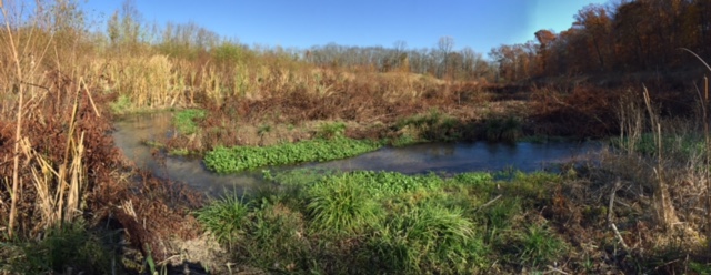
Aquetong Lake at the intersection of Route 202 and Lower Mountain Road, a fixture of Solebury Township since circa 1870, is gone! STHS has documented the changes in the lake area as it returns to a stream. Our purpose is to answer for coming generations the age-old history question, “What did it look like when it was there?” We have posted photos and explanations of the dam’s deconstruction, the stream seeking its new channel, and the landscape returning to its once-lost state. The next phase of the project is the making of a park that can be used by all residents. Click to see the progress.
Many people are helping in this documentation effort. We initially want to acknowledge and thank the Township Supervisors and Dennis Carney, the Township Manager. In addition, the Aquetong Water Association and Bucks County Chapter of Trout Unlimited members have been most generous with their time, actions, and ideas. And last but not least, thanks for the support of Solebury Township Historical Society members who recognize the value of documenting and preserving our history. This is a fun project as we get to recognize and record history as it happens, a rare event.
We will continue to seek out old photos of the lake and lake activities to bring past days alive. You can help by sharing photos of the area, either by donating the actual photographs or by scanning and sending them to us for our web site collection along with a short description and date of the photo to be used as a caption. Please email aquetongproject@soleburyhistory.org. If you have photos you want to keep but cannot scan, please call 215 297 5091 and leave a message for Beth.
History
The spring known as Aquetong by the original inhabitants of the land, the Lenni-Lenape, and known as Ingham Springs by European settlers is located just off Lower Mountain Road in Solebury Township. The spring water that flows at the rate of 2,000 gallons per minute was used to power mills along the Aquetong Creek. In 1870 a dam was built to create the lake, and now that dam has been removed and the creek will return to its natural, pre-1870 state. The area of the former lake and its surroundings will be transformed into Aquetong Spring Park.
The Society is adding newspaper articles and other documents about the lake, the spring, and the area. Check out what has been added.
Photographs/Videos
The Society is documenting the return of the area to its natural state by taking a series of photographs over the course of the years of the project. This map shows the locations where sequential photos are being taken. Click on a pin marker to see the changing scenery.
The Bucks County Chapter of Trout Unlimited and the Aquetong Watershed Association prepared an aerial video of the lake in late April 2015 just before work began. In July 2015 Jacob Borden, assistant district manager of the Bucks County Conservation District captured the moment the water broke through the last barricade to flow naturally. In August 2015 Bill Squitieri of A-Stat Inspection Services, Doylestown, sent up his drone to film the stream that has formed. Watch these videos here.
The lake takes on different feelings in different seasons.
Interested in the changing flora and fauna?
What structures are on or near the property?
The Aquetong Creek runs from the lake to the river. It will change slightly as the lake slowly disappears.
Old photos and postcards show us how the area has changed. If you find and submit old photos, this is where they will be.
Photographers
The Society would like to thank the official photographer who has braved the cold winter of 2015 and the warm summer days of humidity, bugs, and mud to record the lake and spring through the changes and seasons.
Don Schoenleber (DWS)
Don is a local photographer who has exhibited his work at the Phillips’ Mill Photographic Exhibition, Stover Mill Gallery, Rich Timmons Fine Art Gallery, the Bucks County Project Gallery, and the Bucks County Audubon Society. He has won award for his photography at the Salmagundi Club in New York and the Philadelphia Sketch Club.
Don’s statement:
I think of photography as an accumulative experience. The more I work at it the more I see the world around me. It makes me slow down and appreciate the subtleties, the time of day and the color of the light. Early morning is my first choice. Its warm, soft, directional light helps bring out the form and texture of the landscape. But it doesn’t last. Everything around us is changing, that is why I feel so strongly about photographing Bucks County and the surrounding area. It’s my attempt to preserve what I see and find so satisfying.
Additional photographers
Beth Carrick (EMC), former vice-president and web consultant of STHS
Richard Todd Halblieb (RTH), site manager for Flyway Excavating, Inc.
Les Isbrandt (LRI), president of the Aquetong Watershed Association


